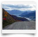
This road is Remarkable2! First, it’s the 13km gravel access road for The Remarkables ski fields. Second, it’s about the highest public-access road that you can drive in NZ, ending at the 1,600m Remarkables Ski Area Lodge—an incredible 1,300m above the lake’s 308m level! And third, Tourism Qtown doesn’t tell you about a FREE drive up this road as an area attraction, even though the views along the road are car-stop, jaw-drop, cameraclick dazzling! Amazingly, neither the mainstream guidebooks nor any tourist literature mentions this do-it-yourself venture. Is there no room in “Adventure-town NZ” for anything that’s free?? Driving up the Remarkables in summer is definitely where Tourism Q-town doesn’t want you—they want your butt in a Jetboat, bungy harness, 4WD tour, raft, funyak, etc etc. For do-ityourselfers the FREE drive up the Remarkables is a must-do. You’ll revel in the glories of Queenstown’s true beauty as the views sweep from peaks to lakes to rivers to EVERYWHERE.
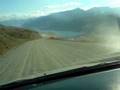
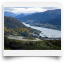
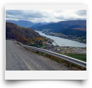
DRIVE: The Remarkables Rd is off of SH 6 just south of Q-town and Frankton—3km south of the Kawarau River Bridge. The views on the drive begin almost immediately up the road, but 4km up is a looping pulloff worth a first gawk. At the 6km mark there’s a parking area and short path up to the 900m Trig’s PHENOMENAL view, both out over the lake and down directly below at the confluence of the Shotover and Kawarau Rivers. You’ll see the milky Shotover River actually blending with the crystalline Kawarau River, making the Kawarau a bit more opaque as it flows towards those splash-ing bungy’ers bouncing around a few kms downriver. Above the Trig the views don’t dramatically improve too much, so turn back there if you don’t like cliff-edge washboard road. The Lodge itself isn’t too scenic, but the tracks from the lodge are. Remarkables, here you come!
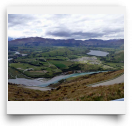
Lake Alta. Lake Alta is a small turquoise teardrop of a lake nestled under the ominously jagged peaks of The Remarkables. The Lake Alta Track is just a short 30-minute one-way walk (200m ascent) up from the Remarkables Ski Lodge. The lake is a classic cirque lake filling a glacially scoured basin with the super-scenic black crags of 2,319m Double Cone towering above. From the lodge you can’t see the lake’s basin. Until you walk half-way up the track you’ll have no idea how dramatic the view is going to be, nor how sapphire blue a lake can be.
WALK: From the carpark head up and around the lodge’s right side on the road. Skip the immediate right turn that heads to Shadow Basin and continue 5 minutes up the road to the next signed junction. Go right and up this steeper road. At the top of this incline, as the road turns sharply right, look for the marked track near the bog which heads up the rocky slope to the lake.
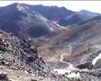
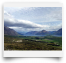
Shadow Basin Lookout. The Shadow Basin Lookout defies description— it’s too good! This viewpoint is one of NZ’s finest alpine views, yet it receives little-to-no publicity. A crowded day is you and a Kea. The lookout is perched at 2,000m on the jagged rocky ridge immediately below Single Cone. Surprisingly, the trek to the view is only 40-45 minutes climbing 400 vertical meters from the ski lodge, all on a ski-field “road”. The island’s other showcase high-alpine viewpoint—Avalanche Peak at Arthur’s Pass, is about the same altitude but requires an arduous 2-3 hour trek to get the view. The adjective-defying view of Shadow Basin is almost too good to be true! Not just Q-town and pretty blue Lake Wakatipu sprawling below…not just airplanes zooming the runway over the Shotover River delta, not just Coronet Peak and Ben Lomond looking like mere bumps….the MOST AMAZING aspect of this view is that, on a clear day, all of Fiordland’s peaks shine! The horizon is wall-to-wall snow-capped peaks! Sight Glenorchy’s 2,820m Mt Earnslaw, with its glaciered crown, directly above the Shotover bridge. Look for the pointy peak of the Milford Road’s Mt Christina (rising above Lake Marian) in the distance above and just left of the Kawarau bridge. Basically, on a clear day, this may be the most bang-for-the-buck view available any-where in New Zealand!
WALK/TRAMP: From the carpark you’ll be following the chairlift that runs up the steep waterfall hill to the right of the lodge. Begin around the lodge on the road and take the first right turn. This rugged “road” now goes all the way to the top of the chairlift, the first half being easy and the second half more steep and rough. Reaching the lift’s top, a path begins to the left of the ski field map. It quickly zigzags through the rocks to the lookout. (FYI: it looks like the rocks to the left of the lookout might have a killer south view. They don’t.)
Coming down, it’s possible to skirt across the northern ridge on the ski road and then rock-hop down to the pond/ski lift to make a loop.


Comments
Steep drive on gravel road.
Great views of Queenstown and
The most amazing views of the