Egmont National Park is contained within the strange circular boundary you see on every Taranaki map—the “ring plain.” The ring, besides being the legal border of the park, is actually a definitive border between forest and field. Virtually every acre outside the ring is pasture or crop land and every acre inside is forest. The plains encircling Mt. Taranaki are some of NZ’s most productive agricultural lands thanks to the volcano’s nutrient-rich ash.
There are three main ways to visit the National Park, each road-end with its own charms.
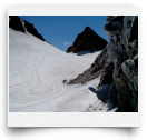
North Egmont Visitor Center is fastest from New Plymouth and at its 952m carpark there’s a café and info center. This is the start of the popular, yet dangerous, track to the summit. Don’t even think about attempting this summit without prior knowledge of conditions, gear, supplies, and brains. This mountain, while looking harmless and inviting in the sunshine, will turn on you quicker than a pit bull near a baby! On a lighter note, there are short walking tracks thru goblin forest and a good day-walk looping together the Summit track and the Holly Hut track (2.5-3 hours, 500m climb to Tahurangi Lodge then over to Holly Hut/ Razorback ridge. Go clockwise.) This track sports good views of Tongariro’s peaks, New Plymouth, and the coast north to the White Cliffs.
East Egmont is accessed from Stratford up Pembroke road. This is the road up to the Manganui snow fields, but during summer there’s nothing going on up here except views and tracks. The road ends at the highest drivable point on Mt. Taranaki—the 1172m “Plateau.” This road-end is the least touristy of the three and it makes for an excellent freedom campspot if the weather is clear. If it’s cloudy then it’s cold and lousy. There are no short, easy touristy tracks here, but you can do my favorite loop in the park from here as well as from Dawson…see Dawson for deets.
Dawson Falls Visitor Center, at 902m, is world-famous for its namesake 18m waterfall. Dawson Falls has the greatest variety of track options. Short scenic loop tracks visit the waterfall, Wilkies Waterfall pools, a high swing bridge, and the “goblin” forest. The “goblin” forest at Dawson is surreal—gnarled trees surround you with moss-draped twisting branches while roots criss-cross the path in their attempt to trip you up. Very different from all the other lowland NZ bush.
A good medium length walk is to loop together Wilkies, the Ridge, and Kapuni/Dawson Falls— it’s 1.5 hours of streams, goblins, views, and waterfalls.
Better yet is my favorite loop tramp in the entire National Park. It’s a 2.5 hour loop connecting Wilkies Pools, East Egmont’s “Plateau,” the Enchanted track, and the Waingongoro Gorge swing bridge track. This difficult tramping loop packs it all in! Go clockwise…up to Wilkies Pools then a 45-minute climb up to the Plateau carpark viewpoint (passing the Enchanted track for now.) After a view and a snack, backtrack to Enchanted and head down its mile o’ steps. Turn right at the Waingongoro track, up and down thru some streams, then across Egmont’s highest swing bridge. Detour 5 minutes to see the hut, then another 40 minutes of tiring up and down back to Dawson. Ahhhh, fetch some cold ones outta the chillybin and head to the Falls or up to the view platform.


Comments
At good weather try to climb