This is the slow road to Picton from Blenheim for those who want to savor the South Island just a little more before heading North (coming South from the ferry most folks are too amped up to get to Nelson/Golden Bay or Kaikoura to enjoy this slow leisurely delight.) This 42 km road (about two hours drive) from Rarangi Beach to Picton is one of the windingest on the island—and half of its length is unsealed, but still a good road. Make no mistake, this road is slow as it visits a handful of intimate coves and then rises up to skirt the view-packed headlands in between. But the sights are plenty and you’ll DEFINITELY be OFF the tourist track…and you’ll get a taste of driving one of Marlborough Sounds’ super-curvy roads, but this one actually delivers you to a new place, rather than the out/ back chores that are that are the Queen Charlotte and Pelorus roads. If you’ve got a ferry booked, then maybe make this your final venture on the South Island. If you camp at DOC’s Whatamango Bay, then Picton is just an easy 15- minute drive, making the Port Underwood Rd drive a slow peaceful farewell to one of the most amazing places in the world—the South island of New Zealand.
Here’s the rundown on attractions and options, listed south to north:
Rarangi Beach: $6 DOC campground on a looong shingle (pebble) beach. At north end of beach is a staircase over to cute little sandy Monkey Bay. At the staircase the plaque details Daddy Watson’s cave—bring a torch and have a look—it’s directly in front of the plaque in the bush—and it goes in a surprising 60-70 meters and sports a few glow worms.
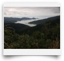
Whites Bay. About 6km north of Rarangi, and this first 6km is typical of the up/down on the entire route (but the seal ends at Whites for the next 20km to Oyster Bay.) Whites Bay has a spacious, yet sheltered, $6 DOC camp with toilets and showers. There are also a couple of walking tracks and an explorable beach arch. The best track is Black Jack Lookout loop which is a steady uphill of 25 minutes to the view, then 20 back down (left at the upper junction). From the viewpoint you’ll see Cape Palliser, Port Underwood, and probably a ferry making the crossing.
Robin Hood Bay. The biggest and sandiest bay on the route, but still intimate. Free Doc camp on south side with heaps of day-use parking along the entire bay front. Toilets on either end. Low-tide tide pools are fun to explore.
Ocean Bay/Bob Canes Bay. Small coves with water access, but no sandy beaches. Bob Canes has waterside picnic grounds. Neither is too exciting. Oyster Bay. The road becomes sealed here again for the drive up over the hill towards the Sounds and Picton. Oyster Bay has some cottages and a wharf/boatramp, but nothing too scenic for travelers. From here the road leaves Port Underwood and climbs the hill over to the Sounds, with a good pull-off view-stop at the top of the grade.
Whatamango Bay. Large $6 basic DOC camp on an arm of the Sounds. Good kayaking. Nice place for the first/last night on the island.