Skip to contentSkip to navigation

Tokatoka Peak

Track Up Peculiar Peak

Difficulty: Short but straight up about 80m
Bring: 420 supplies, area map
Tokatoka Peak
NZGps: 36° 3' 30.5676" S 173° 58' 37.7724" E
3
Average: 3 (1 vote)

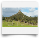
Tokatoka Peak, the spiky remnant of an ancient volcano, decorates the feature deprived landscape north of Kaipara Harbor. Heading north you can see its pointy protrusion soon after leaving the Kauri Museum. Heading south from Dargaville it looks like Mother Nature is giving you the finger. Either way you can’t miss it once you’re near.

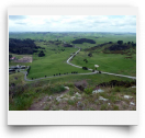
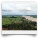
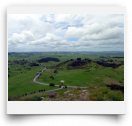
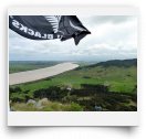
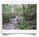
There’s a “steep-as” track to the top which is basically an 8-10 minute dirt staircase—about 420 steps according to a local stoner. Don’t go if it’s wet—it’ll be more slippery than a politician’s palm. The view from the top is worth the effort—Bream headlands to the east, Glinks Gully to the west, Maunganui Bluff to the north, and the river at your feet.

Excerpt from "NZ Frenzy Guidebook" by Scott CookNZ Frenzy Guidebook

Videos

Member Photos

Location Map

Comments

I went here after plenty of

beatsmilking's picture

I went here after plenty of rain - and the track up wasnt too bad, perhaps because its steep - the worst bit of mud was the field crossing at the lower level (but thats real short).
What I did find near the top was an ever increasing number of sand flies - maybe the rain, or the time of year - or maybe they just like being high up - but towards the top I was climbing with a face full of them - the pinnnacle is only 1 man width so theres no escape!
The top was flying an All Blacks flag (for the Rugby World Cup) - Oh how I wished I was from a visiting World Cup nation to replace it with my own teams!
Good view from the top - and didnt take long to get there, so why not!

3

Submitted by beatsmilking on Tue, 2011-11-08 23:52