The East Cape road from Opotiki to Gisborne is 320km of wild, uncommercialized North Island. Sweet as! This road isn’t part of any typical tourist track, and I don’t intend to steer it that way either. No dolphin safari, no sky dive, no bungy, no zorb…just bays and beaches and beauties. Don’t hurry the East Cape! This isn’t the kind of “frenzied” place to hurry to the next attraction… the road is slow…the pace is slow. In my mind the East Cape is a bit about finding your own places, your own adventures…so I won’t try to say too much here…but rather just give you some stopping points, camping points…and one must-see (Tolaga.)
From Opotiki:
Torere Bay. 21 km from Opotiki. The west end of this long pebbled beach has long been popular with freedom campers, courtesy of the local Iwi. From the west, descending the hill, as the road straightens, turn left at the white fence, head to the beach and find a mile of free camping.
Whanarua Bay. Just north of Te Kopua. Pay campground. Heavenly bay. Hire kayaks…explore! Find waterfall. Hicks Bay. Go see the wharf at the beach’s North end.
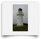
Te Araroa-East Cape Lighthouse. The lighthouse is 20km from town, half unsealed but the road is good and fast. The lighthouse itself is at road’s end up a gob of stairs…lonely and wind-whipped, but strangely compelling. The drive is the real beauty! No camping at the Light, but some scattered a few kms back.
Waipiro Bay Loop road. Yup, haven’t seen a beach in a while.
Tokamaru Bay. Wharf and ruins and camping.
Anaura Bay. 100% Pure New Zealand advert. Bush tracks. Definitely!!
Tolaga Bay. See entry next page.
Whangara Bay. “Whale Rider” village. Ho hum.