The Rob Roy Glacier-view trailhead is a long gravel drive from Wanaka…is it worth it? Yes, emphatically yes. Other than Mt Cook’s Hooker Valley Track, the Rob Roy Glacier viewpoint may be the WOW-est day-walk viewpoint in the Southern Alps. Put this track on the must-see list!!
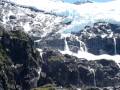
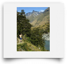
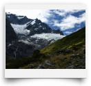
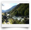
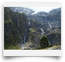
The track first runs alongside the ice-blue Matukituki River before swinging you across for the climb into the Beech-clad Rob Roy Valley. As you now climb up through the thickly-forested valley you’ll be accompanied with the constant roar of whitewater below. After a pre-emptive view of a knock-yoursocks- off impressive ribbon of waterfall, you’ll arrive at the final viewpoint…and WHOA! A panoramic glacial amphitheatre of indescribable majesty unfolds before your eyes!! Waterfalls roar all around, pouring off the blue tongues of Rob Roy’s snowy heights. Jagged peaks encircle the valley while wildflowers carpet the floor under foot. To top off the umph, as you sit pondering the juggernaut enormity of the scene, a friendly Kea may fly up, check out your zippers and have a munch on the nearby wildflower buds. If you’re lucky enough to have your eyes peeled when the glacier calves a huge thunderous hunk…well, good on ya! Bring lunch and expect to spend at least an hour at the trail’s end viewpoint!
The Rob Roy Glacial amphitheater is impressive2! I can’t praise it enough. At most viewpoints you get an eye-full and then that’s enough (Milford, Franz Josef, etc). But at Rob Roy the scene captivates with its constantly changing nature…the 1000-foot waterfall wisps back and forth, the Keas fly, swoop, call and land, the waterfalls roar, the glacier calves. This is riveting NZ wilderness! In a nutshell, don’t miss this spot!!
WALK: From the carpark it’s 15 minutes of easy walking to the scenic swingbridge. From there the trail steepens considerably for 25 minutes of roots and rocks, then moderates for the final 40 minutes to the trail’s end view-rocks. After a large eye-full of glacier-rama and Kea lovin’, maybe head down a few minutes to the rushing stream for a different vantage.
FYI: You can get over to and under the huge wispy waterfall, but it’s not easy. Wade the stream, push through the brush/bush, up the marshy grass…and you’ll be rainbowed under one of the South Island’s highest pure free falls.


Comments
Weren't able to get to route.
We left really early in the