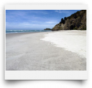
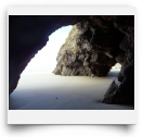
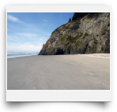
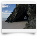
Mapoutahi Head is the ridge that separates Purakaunui and Blueskin Bays north of Port Chalmers. Three long white sand beaches adorn the northfacing coastline here, with some intimate low-tide coves adding some pizzazz. The white sand beaches sparkle in the sun with the blue waters and green hillsides nicely contrasting the arcing sands. The headland is evenly divided into three 1km-long sections, each completely different than the others. The eastern third is a simple long stretch of sand backed by wisping grasses with conical Mt Purakaunui and its bay inlet beckoning ahead. The middle section begins up some steps with an optional quick uphill to a scenic Pa point. Once down on the beach—whoa—a dramatic stretch of white backed by 100m cliffs with the Waitati-Osborne railway perched above. At the western end of this section two sea-cave tunnels escort you out onto Blueskin Bay’s low-tide-only Doctor’s Pt beach stretch. This section follows the bay’s outflow stream as far as Doctor’s Point Reserve carpark.
A high tide swamps the seacave tunnels and most of all the beaches, so try to plan a mid-tide or lower visit. At low tide you could park at Doctor’s Point for a fastpaced walk of the 3km total stretch, but if you plan to linger for awhile and don’t want to worry over the tides, then it’s best to drive further to the Mapoutahi carpark area.
FYI: The more-eastern Long Beach (signed off the Mapoutahi Rd) has a huge dune-locked sea-cave on its NW end that’s big enough for all Otago University to party in…and they do—check it out! The rocks near the cave also sport some short rock-climbing routes.